Well design ASCII file format
OBJECT WELLDESIGN
[CRS Authority Code Name HorizontalUnit]
[CSYSTEM Easting Northing TVDSS Inclination Azimuth]
[UNITS EastingUnit NorthingUnit VerticalUnit InclinationUnit AzimuthUnit]
[COLOR Red Green Blue [Alpha]]
[UNKNOWN UnknownValue]
[TYPE WellDesignType]
[DLSUNIT DlsUnit]
[TargetName] Easting Northing TVDSS Azimuth Inclination Dls
....
Keywords (the order of these keywords does not matter, except from the OBJECT keyword – this keyword should always be the first one).
| Keyword | Description | Optional | Comment |
|---|---|---|---|
|
WELLDESIGN |
Specifies the object type in this file |
No |
One value is expected: 1. Name of the well design |
|
TYPE |
Specifies the WellDesign type |
Yes |
One value is expected: 2. Type of well design (default = UNDEFINED) When this keyword is not included, the default type is applied. |
|
DLSUNIT |
Specifies the dls units |
Yes |
One value is expected: 1. Dls unit (Default = m/rad) For the Depth the unit can be: 1. rad/m (radians/meter) – default unit 2. rad/ft (radians/feet) 3. deg/m (degrees/meter) 4. deg/ft (degrees/feet) 5. deg/10m (degrees/10 meter) 6. deg/30m (degrees/30 meter) 7. deg/30ft (degrees/30 feet) 8. deg/100ft (degrees/100 feet) When this keyword is not included, the default unit is applied |
Variables
| Variable | Description | Type | Min | Max | Comment |
|---|---|---|---|---|---|
|
Type |
Type of WellDesign |
int |
14 |
0 = UNDEFINED 1 = RBWATINJ 2 = STBWATINJ 3 = RBGASINJ 4 = MCFINJ 5 = STBOIL 6 = MCF 7 = MCFWET 8 = STBLIQ 9 = RBTOT 10 = RBOIL 11 = RBGAS 12 = RBWAT 13 = RBLIQ 14 = STBWAT |
|
|
DLsUnit |
Dls unit to be used |
string |
- |
- |
Default = rad/m |
|
TargetName |
Name of the target |
string |
- |
- |
No spaces allowed – optional |
|
Northing |
Northing station location |
double |
- |
- |
|
|
Easting |
Easting station location |
double |
- |
- |
|
|
TVDSS |
TVDSS station location |
double |
- |
- |
|
|
Inclination |
Inclination value at station |
double |
0 |
180deg |
|
|
Azimuth |
Azimuth value at station |
double |
0 |
360deg |
|
|
Dls |
Dls value at station |
double |
- |
- |
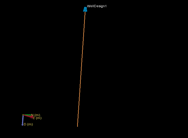
Example 1 (vertical well design)
OBJECT WELLDESIGN Plan1
CRS EPSG 2222 "NAD83 / Arizona East (ft)" ft
CSYSTEM 569000 168000 1600.0 0.0 0.0
UNITS m m m deg deg
COLOR 255 255 0 255
TYPE STBOIL
DLSUNIT rad/m
Target_0 1750 1750 0 0 0 0.002
Target_1 1750 1750 115 0 0 0.002
Target_1 1750 1750 510 0 0 0.002
Target_2 1750 1750 800 0 0 0.002
click to enlarge
Example 2 (deviated well design)
OBJECT WELLDESIGN Plan2
CRS EPSG 2222 "NAD83 / Arizona East (ft)" ft
CSYSTEM 569000 168000 1600.0 0.0 0.0
UNITS m m m deg deg
COLOR 255 255 0 255
TYPE STBOIL
DLSUNIT rad/m
Target_0 2450 600 0 0 0 0.026
Target_1 2450 600 120 0 0 0.004
Target_2 1850 875 450 155 82 0.002
Target_3 750 1525 430 148 92 0.002
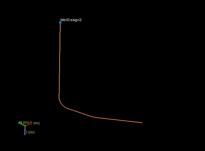
click to enlarge
Example 3 (minimum / all optional fields left out)
OBJECT WELLDESIGN Plan3
550 550 0 0 0 0.002
550 550 1200 0 0 0.002
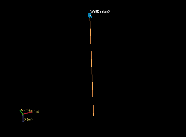
click to enlarge