3D grids
click to enlarge
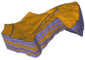
This data type represents the subsurface reservoir data in complete 3D (width, length, and depth). It is characterized by a regular arrangement of cells in three directions. Each cell typically contains one or more properties, such as porosity, layer number, thickness, volume, etc.The proprietary JewelGrid is used by the application when building geological and simulation models. Regular IJK grids can also be used, allowing for compatibility with other reservoir modeling tools.
For many of the human-readable 3D grid file types that follow, an example is provided of the required file format to help you identify the type of a file to load.
ECLIPSE™ grid (*.ecl, *.grdecl, *.inc)
-- Format :
-- Exported by :
-- User name :
-- Date :
-- Project :
-- Grid :
NOECHO
PINCH
/
MAPUNITS
'METRES' /
MAPAXES
0.0 -1000.000000
0.0 0.000000
1000.000000 0.000000 /
GRIDUNIT
'METRES' /
SPECGRID
108 74 2 1 F /
COORDSYS
1 2 'INCOMP ' /
COORD
372630.454698 -5960742.234756 3091.366699 372885.968403 -5960943.097755 4047.524414
372692.881451 -5960669.964890 3090.605225 372955.699985 -5960875.049725 4056.346680
372755.308203 -5960597.695025 3089.735352 373025.431568 -5960807.001695 4067.745605
372817.734955 -5960525.425159 3088.780762 373095.163150 -5960738.953664 4082.164551
372880.161708 -5960453.155293 3087.822021 373164.894733 -5960670.905634 4100.092773
…..
SGridSet(c) (*.joasgridset, *xml)
The internal XML based file format for geological and simulation 3D grids.