Grid scale and elevation factors
Applying the grid scale and elevation factors during import of a deviation/directional survey can for some wells significantly improve the positional accuracy of the wellbore. An extreme example is a wellbore with a very long horizontal section (e.g. 10 kms), located at a very high latitude (e.g. > 80 deg) within a UTM projection. In other circumstances applying the grid scale and elevation factors will make a negligible difference or none at all (e.g. for vertical wells).
Grid scale factor The grid scale factor converts an ellipsoidal length (i.e. a geodetic distance based on the Earth model) to a length on a map projection surface (i.e. a grid distance), and vice versa. It varies according to the type of projection in use and where the measured length is located on the ellipsoid. For UTM projections, the grid scale factor is optimal where it is 1, which is at the location where the projection surface intersects with the ellipsoid: from there, the grid scale factor decreases (<1) in the direction towards the Central Meridian, and increases (>1) in the direction away from the Central Meridian. The grid scale factor represents the ratio of the true map scale to the stated map scale for a particular location, since no map has true scale everywhere.
Elevation factor The elevation factor converts the horizontal distance along the line of mean elevation between two points, at the Earth surface (or below it), to the ellipsoidal length (geodetic distance), and vice versa.
Thus the product of the grid scale and elevation factors converts distances measured on or below the Earth surface to those on a grid projection, and vice versa.
If you choose to apply the combined factor when importing a wellbore via a deviation survey, JewelSuite Subsurface Modeling determines and applies the combined factor at each depth station along the wellbore: the intermediate cubical coordinates derived at each depth station are multiplied by the combined factor to arrive at the projected position log coordinates. If you choose to apply the combined factor when importing a wellbore via a position log, JewelSuite Subsurface Modeling back-calculates a deviation survey from it via the inverse minimum curvature algorithm. Both grid scale and elevation factors are obtained from Blue Marble.
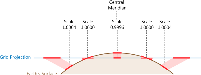
Schematic diagram (for UTM projection) showing how the grid scale factor varies with its distance from the Central Meridian. The grid scale factor is 1 where the projection surface intersects with the ellipsoid; from there, it decreases (<1) in the direction of the Central Meridian, and increases (>1) further away from the Central Meridian click to enlarge
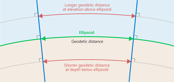
The elevation factor is used to convert measurements above or below the ellipsoid, to the ellipsoidal equivalent. The diagram shows how this factor changes with height/depth: for measurements made above the ellipsoid, the elevation factor is <1, for measurements made below the ellipsoid, the elevation factor is >1 click to enlarge