The JewelGrid System
The JewelGrid represents a unique solution to 3D gridding at the heart of the JewelSuite Subsurface Modeling application. This section provides a brief description of the JewelGrid and its advantages over other methods. It also provides some background as to how the grid is created and used in property modeling and reservoir simulation.
Why construct a JewelGrid?
Other approaches
Most reservoir modeling applications discretize the reservoir volume into cells. Cellular grid designs have evolved over time usually as a requirement to capture more complex structural topology. First generation regular (voxel) grids with verticalized faults were replaced by a second generation of grids including the ubiquitous pillar grid. The pillar grid has cell boundaries aligned with geological faults and horizons. Whilst this alignment is desirable for stratigraphic surfaces, the alignment of the grid with faults, generating a pillar grid, generates a number of challenges such as:
- Strong cell distortions at surface intersections (e.g. fault-fault intersections and fault cutoff lines).
- Limitations on the fault and horizon topology to be modeled. Low plunging fault-fault intersections (e.g. Y-faults) are geologically pervasive, yet impossible to represent.
- Inclined vertical cell stacks caused by the requirement for them to align with adjacent dipping faults. Strongly inclined grid stacks can result in sub-optimal simulation results, for example in gravity-dominant flow in fractured reservoirs.
- The lateral distortion of geological objects created in orthogonal modeling space (e.g. channels) during the transformation back to structured i,j,k node locations.
- A non-orthogonal grid which is not appropriate for finite difference methods (e.g. reservoir simulation).
- The inability to rotate the grid to check the impact of grid orientation on fluid flow.
- The difficulty in extending the pillars to the surface.
To overcome these issues the user has to compromise on the structural integrity of the model by either simplifying the structural input, slicing the model into sub-models of limited stratigraphic extent or making a more orthogonal grid by compromising on i,j alignment (zig-zag faults) or j alignment (stair-stepped faults).
These shortcomings have led to a third generation of grid designs such as the UVT Grid (J.L. Mallet 2008, Numerical Earth Models, EAGE Publications) in which a transformation is calculated to convert the structural model into orthogonal parametric space. The reverse transform creates the cell boundaries in structured geological space. In this representation, complex fault-horizon interactions are captured. Also, the parametric space is a better representation of paleo-space allowing for a truer representation of geological body dimensions. However, the uvt-transform does not account for internal structural deformations and also assumes a flat datum (e.g. there is no paleobathymetric correction) so the parametric space is, at best, a representation of original depositional space. A key drawback of the UVT Grid is the inability to perform reservoir simulations without conversion to stair-stepped fault geometry.
Benefits of the JewelGrid
The JewelGrid is another third generation grid design which offers a simpler alternative to the pillar grid and UVT Grid approaches. The JewelGrid is a structured areally-rectangular grid with vertical cell stacks. The grid is locally unstructured where faults pass through these vertical cell stacks and cells are split exactly where intersected by interpreted faults. Thus, there are virtually no restrictions with respect to geometry and topology.
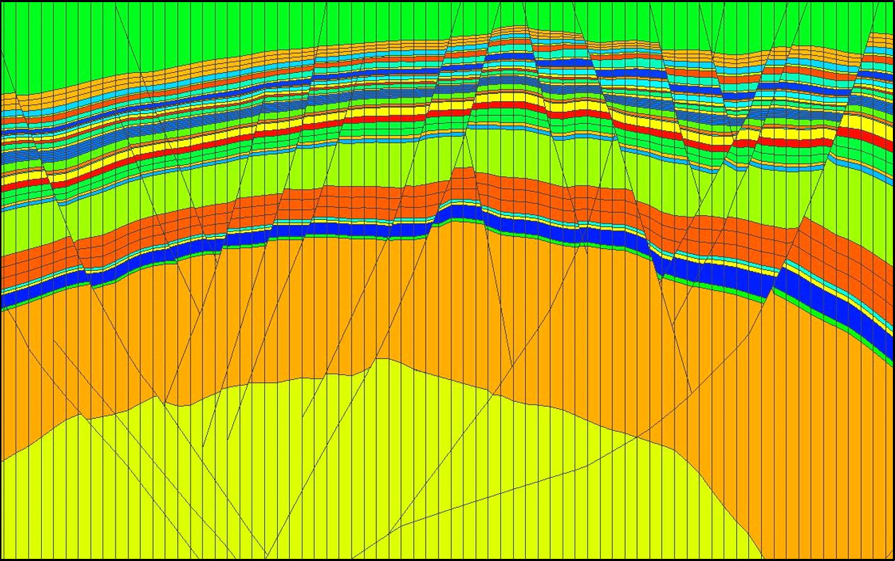
Cross section through the JewelGrid click to enlarge
The simple orthogonal stack sets of the JewelGrid provide a number of advantages over other grid designs.
The immediate benefit of the JewelGrid is the ability to represent true geometrical topology. Structural geometry is not compromised. Fault tip lines are represented by true elliptical polygons which can terminate laterally and vertically within the grid. Fault-fault intersections (branch lines) are correctly characterized and horizontal branch lines (e.g. Y-shaped faults) captured without recourse to cell distortion or stair stepping. Depositional geometry is also optimized. For example, the true layer truncations are preserved at erosional boundaries, such as channel margins (see below) resulting in the correct description of connectivity.
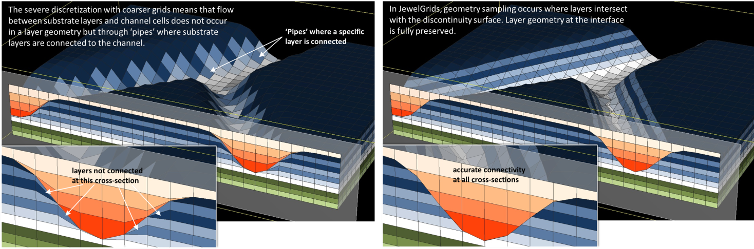
Channel truncations in the pillar grid (left) compared with the JewelGrid (right) click to enlarge
The vertical alignment of stack sets also allows for an improved description of gravity-dominated flow. This is particularly important in fractured reservoirs where hydrocarbon columns can be high and gravity is the dominant force. In such reservoirs permeability is often aligned along (sub-)vertical natural fracture conduits. The connectivity in fracture corridors is best preserved in the vertical stacksets of the JewelGrid.
Once the 3D fault-horizon network is constructed, the creation of the JewelGrid is a rapid process which does not require the intense user interaction of a pillar grid update.
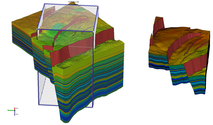
Rapid generation of a sector model (right) from an existing JewelGrid (left). The Area Box shown in the left hand view controls the model boundary click to enlarge
This performance advantage allows for rapid grid updates. This quick slice-and-dice approach enables the user to test the impact of grid orientation on property modeling and simulation results and to quickly create multiple sector models from a single full-field model. There is no azimuthal constraint on the grid orientation.
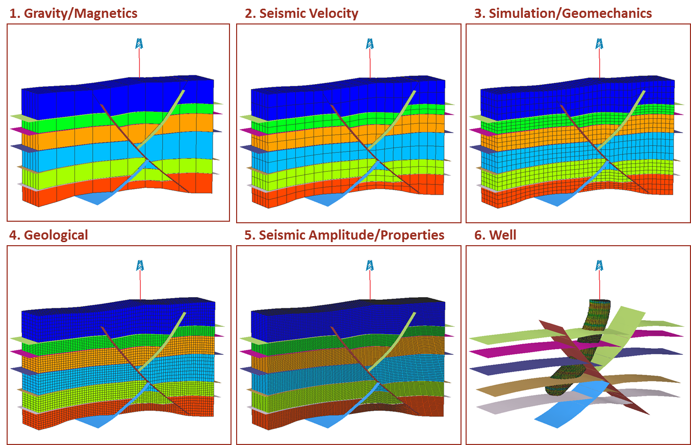
The JewelGrid expressed at multiple fidelity levels click to enlarge
In addition to changing grid orientation or area-of-interest the orthogonal array of the JewelGrid has the additional advantage in that it allows for rapid upscaling and downscaling enabling multi-scale modeling workflows. An individual solution can contain more than one JewelGrid representing the subsurface at a range of scales (e.g. wellbore-scale, through geological-scale to flow-scale and ultimately seismic-scale).
The vertical stacksets of the JewelGrid make it easy to incorporate overburden (to surface) and underburden as single layers or at lower vertical cell resolution. The JewelGrid therefore provides a useful container for geomechanical and geophysical applications and as an input to basin modeling exercises. This property also allows multiple, stacked reservoirs to be included in a single grid.