Wellbore deviation surveys - Minimum Curvature method
Minimum Curvature
When a wellbore is created from a deviation survey, JewelSuite Subsurface Modeling uses the industry-standard Minimum Curvature algorithm to derive a position log from the deviation survey.
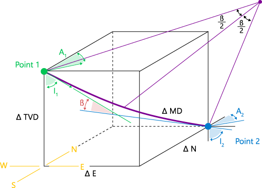
3D visualization of the minimum curvature issue click to enlarge
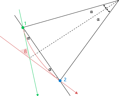
2D visualization of the minimum curvature issue. α = β / 2. In green the known data, in blue what is computed in the forward calculation, in red what is computed in the inverse calculation click to enlarge
Given:
- Northing, Easting, (True Vertical) Depth, Azimuth and Inclination of Point 1
- Azimuth and Inclination of Point 2
- Path length or MD between Point 1 and Point 2
Calculation of Northing, Easting and (True Vertical) Depth of Point 2 according to:


where:
I = Inclination
A = Azimuth
E = Easting
N = Northing
TVD = (True Vertical) Depth
MD = Measured Depth
Inverse Minimum Curvature
When a wellbore is created from a position log, JewelSuite Subsurface Modeling uses the inverse Minimum Curvature algorithm to derive a deviation survey from the position log.
Given:
- Northing, Easting, (True Vertical) Depth, Azimuth and Inclination of Point 1
- Northing, Easting and (True Vertical) Depth of Point 2
Calculation of Azimuth and Inclination of Point 2 and the arc length or MD between the Point 1 and Point 2 according to:


where:
I = Inclination
A = Azimuth
E = Easting
N = Northing
TVD = (True Vertical) Depth
MD = Measured Depth